The National Planning Policy Framework (NPPF) as published on 20th July 2021 states this about protecting Green Belt land:
137. The government attaches great importance to Green Belts. The fundamental aim of Green Belt policy is to prevent urban sprawl by keeping land permanently open; the essential characteristics of Green Belts are their openness and their permanence.
138. Green Belt serves 5 purposes:
(a) to check the unrestricted sprawl of large built-up areas;
(b) to prevent neighbouring towns merging into one another;
(c) to assist in safeguarding the countryside from encroachment;
(d) to preserve the setting and special character of historic towns; and
(e) to assist in urban regeneration, by encouraging the recycling of derelict and other urban land.
Below is a history of the development of the Green Belt for Durham City and details of how the Trust and individual Trust members were involved in this process.
Background to the Green Belt
The first “Green Belt” appeared as the Metropolitan Green Belt around London in 1935. The Government’s Town & Country Planning Act 1947 allowed planning authorities to include green belt proposals in their development plans. In 1955 the Government published its Green Belt Circular 42/55 inviting planning authorities to submit proposals for Green Belts giving statutory and permanent protect to areas of primarily open land around cities and between towns. Currently, the Government sets out its policies and principles towards the green belts in the National Planning Policy Framework (as above).
The County Development Plan 1954
Durham County Council prepared the first County Durham Development Plan, under the Labour Government’s Town & Country Planning Act 1947. The Draft Written Statement, Written Analysis and County Map were submitted in 1951 and approved with amendments by the Minister of Housing & Local Government on 19th February 1954. It is essential to refer to the 1954 Approved Plan documents despite the fact that in public libraries and general availability the 1951 documents are most prominent. Only the 1954 Approved documents have statutory force. The Plan designates Areas of Great Landscape Value such as West Durham but nothing around Durham City. A Town Map for Durham City area is promised but never happens.
Draft Green Belt Map under Circular 42/55
Immediately this Circular appeared, the County Council prepared a draft Green Belt Map which it submitted to the Minister at the end of 1955, including a Green Belt around Durham City. In his response in March 1957 the (Conservative) Minister agreed that a partial Green Belt for Durham City should be incorporated in the County Development Plan “to maintain its unique character”. Agreement was reached with the Minister that a partial Green Belt for Durham City to the east, south and west sides of the City could be adopted for the control of development pending the statutory vehicle of an Amendment by way of a County Development Plan Review. Thus since 1957 the partial Green Belt was applied by the County Council to all development proposals within the defined area, and its decisions were upheld by Government Inspectors on appeals against refusals of permission.
The County Development Plan Amendment No 39 1969
Ten years after the 1954 Approved Plan, the County Council submitted a review, update and revision in the form of County Development Plan Amendment No 39. This was approved with amendments by the Minister of Housing & Local Government in 1969. Again, it is essential to refer to the 1969 Approved documents despite the fact that in public libraries and general availability the 1964 documents are most prominent and indeed are often the only version available. Only the 1969 Approved documents have statutory force.
The 1964 Submitted Review proposed the designation of several Areas of Great Landscape Value, and for Durham City it proposed a Green Belt around the west, south and east sides of the city, arguing that there was plenty of room for housing and other development to be accommodated northwards. This proposal accorded with the agreement with the then Minister in 1957. However, the 1964 Minister in approving the Plan with amendments declined to approve a partial Green Belt for Durham City but after negotiations did agree instead to approve the same proposed area as an Area of Great Landscape Value but with the exact wording of the national green belt policy. This device proved successful, again with consistent support by Inspectors on appeals.
The boundary of the Durham ‘Green Belt’ that acquired statutory force with the approval of the County Development Plan Amendment No 39 in 1969 is defined precisely in Diagram 15 of the Written Analysis. It does not include the north side of the city, nor does it include Aykley Heads.
The first Durham County Structure Plan
Structure Plans consisted of a broad framework of policies looking forward up to 20 years ahead, supported by a “key diagram” showing land use, transport and environmental proposals diagrammatically (that is, not on a locationally-specific map base). Local Plans, usually prepared by district rather than county councils, were required to accord with the overall strategy set out in the structure plan. It is in local plans that precise boundaries are defined.
The Durham County Structure Plan approved in January 1981 had two strategic policies for protecting the unique setting of Durham City. Policy 98 declared an Area of Great Landscape Value around the west, south and east sides of the City; and Policy 126 required protection of the traditional setting by conserving the wooded slopes and horizons and views to and from the Cathedral and Castle.
The City of Durham Local Plan 1988
Detailed application of the 1981 County Structure Plan strategic policies were set out in the City of Durham Local Plan started in 1978 and adopted in June 1988. Applying County Structure Plan Policy 98, the draft Local Plan proposed a detailed boundary for the Area of Great Landscape Value (AGLV) but the Public Inquiry Inspector modified it by following the County Council’s Interim Boundary adopted in 1980. This brought the inner AGLV boundary tight up against the existing ribbon of housing development west of the A167 and covered the area of the proposed housing site H1.23 at Tollhouse Road which he deleted.
County Structure Plan Review 1999
After a series of annual reports and formal Alterations to update certain policies and to extend the Plan period to 1996, a full review resulted in a new County Structure Plan approved in March 1999. Policy 5 of the 1999 County Durham Structure Plan made provision for a Green Belt in North Durham which extended from Tyne and Wear and encompassed Durham City. The general extent to the Green Belt around Durham was to reach south westwards from Chester-le-Street, east of Kimblesworth, south of Witton Gilbert, east of Bearpark, and southwards to Croxdale and then north-eastwards to Sherburn and West Rainton, to encircle Durham City.
The County Structure Plan 1999 made clear that an all-encompassing Green Belt around Durham City was necessary to preserve its special character and setting which encompasses the high quality landscape and undulating topography of open land around the City along with strategic gaps between settlements. It highlighted the importance of maintaining the strategic gap between Chester-le-Street and Durham City to prevent the linking up of these urban areas.
The City of Durham Local Plan 2004
Work on updating and rolling forward the City of Durham Local Plan started in 1996 and was approved in 2004. Applying the 1999 County Structure Plan Policy 5, the detailed boundaries of the Green Belt surrounding Durham City included land which is vital to the character and setting of Durham City and is likely to be subject to development pressures which cannot be controlled by normal development control policies. It included green fingers of land that penetrate the City at Aykley Heads and Flass Vale; substantial areas of high landscape value around the City, including parts of the Browney Valley and the Wear Valley; and the strategic gap to the north of the City, adjacent to the proposed Chester-le-Street Green Belt.
Saved Polices
The Planning and Compulsory Purchase Act 2004 abolished structure and local plans (just as Durham City’s Local Plan managed to get approved). Instead, Local Development Frameworks had to be produced. In the interim, the Act allowed some local plan policies to be ‘saved’ until they are replaced by new policies in the County Durham Local Development Documents. For Durham City, the Secretary of State agreed to a set of saved policies in 2007. The Saved Policies 2007 continued to be in force until they were superseded by the County Durham Plan in October 2020.
County Durham Plan 2020
Policy 20 Green Belt states “Development proposals within the Green Belt will be determined in accordance with national planning policy.” County Durham Plan p.122 to 126
Role of the Trust
The methods the Trust uses to comment on development within the City are many. We respond to national and local planning initiatives by engaging with consultations, lobbying the council and the national Department for Levelling Up, Housing & Communities, and making our views and objections known at public inquiries. We also respond to individual development proposals with objections and constructive comments, or support where appropriate.
With respect to the various stages of the production of a Green Belt for Durham City, the Trust was active in responding to all the development plans from the 1950s up to the current County Durham Plan, and appearing at all the associated public inquiries. With respect to current development proposals, the Trust upholds the Green Belt and associated national and local policies for its protection in our objections and comments. It is unfortunate that parts of the Green Belt have been withdrawn despite strong objections from the Trust and other organisations and individuals. The largest of these is the release of Sniperley Park for a sustainable urban extension. But there have also been successes e.g. the defeat of plans for the Western Relief Road. On a smaller scale there have also been failures and successes affecting building on the Green Belt, e.g. the shipping containers at Shincliffe garden centre for holiday accommodation were approved; redevelopment of the stables into a residential dwelling at Fernhill on the Newcastle Road was refused.
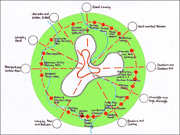
The Trust works with other organisations and individuals in the City. One example is the Durham Green Belt Group who have been very active in protecting the Green Belt and promoting the beneficial use of it as proposed in its Local Plan submissions. Here, the case was made for the provision of better footpaths and cycleways to link villages and the City to visitor attractions and amenities and would be developed for walking and cycling to school and work, while being enjoyed for leisure, education, conservation, sports and amenity use. In essence, it was not only a recreation and leisure initiative, but also one with economic benefits from investments in visitor and tourism infrastructure and social well- being benefits from all that use it (see the schematic diagram below).
A positive example of how the Green Belt can be enhanced is offered by a member of the Trust, David Miller, who is working on Initiative 7 in the Neighbourhood Plan’s ‘Looking Forward’ document. This initiative addresses ‘Identifying, Conserving and Improving Footpaths In and Around Durham City’. David has proposed three trails which are concentric and have the World Heritage Site as the heart of all three.
The three trails are:
The City Centre Heritage Trail (currently under consideration by the Trust and the Parish Council)
The Durham Seven Hills Trail (published by the Parish Council in November 2021)
The Durham Green Belt Trail
David is currently looking for support for a full feasibility study for a Green Belt Trail having scoped a route with a number of alternative sections of route. He is hoping that the National Trust will become a supporter in that the Trust is giving consideration to a green corridor linking Crook Hall Gardens with the wider Green Belt.